funbiogeo
Streamlining Functional Biogeography Analyses
Helps users with analyses in functional biogeography by loading and combining data, computing trait coverage, as well as computing functional diversity indices, drawing maps, correlating them with the environment, and upscaling assemblages.
funbiogeo 


- Overview
- Features
- Installation
- First steps
- Long-form documentation (=vignettes)
- Citation
- Contributing
- Acknowledgments
- References
Overview
The package funbiogeo aims to help users with analyses in functional
biogeography (Violle et al. 2014), the biogeography of
species’ traits, by loading and combining data, exploring the
relationships between traits and their availability trait coverage,
providing many diagnostic plots to understand how to filter them,
producing maps, correlating them with the environment, and helping to
aggregate data at different scales. It is aimed at first-timers of
functional biogeography as well as more experienced users who want to
obtain quick and easy exploratory plots.
Below is a quick introduction to the main features of funbiogeo. If
you want some more details about them, check our
vignettes.
Features
funbiogeo offers:
- Standardized functions to filter and select your data for further analyses,
- Pleasing default diagnostic plots to visualize the structure of your data,
- Extensive documentation (multiple vignettes, well-documented functions, real-life example dataset) to guide you through functional biogeography analyses,
- Nice default plotting functions fully compatible with the outputs of
functional diversity packages (
betapart,fundiversity,hillR,mFD, etc.), - A publication ready, automated, standardized report that provides analyses and plots of your data,
- Functions to easily “upscale” (=aggregate) your data to coarser spatial resolutions whatever the type of aggregation geometry you want (regular grids, irregular polygons, and rasters).

Naming scheme of available functions in funbiogeo
Installation
For the moment funbiogeo is not on CRAN but you can install the
development version from R-universe as
follows:
install.packages("funbiogeo", repos = c("https://frbcesab.r-universe.dev", "https://cloud.r-project.org"))
First steps
This section will show you some useful functions from funbiogeo. For a
longer introduction, please refer to the “Introduction”
vignette.
The package contains default example data named woodiv_traits,
woodiv_site_species, and woodiv_locations all from the WOODIV
database (Monnet et al. 2021). You can, for example,
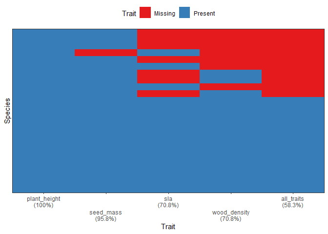
visualize the completeness of your trait dataset (which traits are known
for which proportion of species) using the
fb_plot_species_traits_completeness() function:
fb_plot_species_traits_completeness(woodiv_traits)
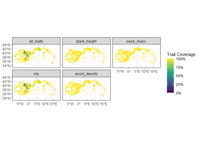
One other useful visualization is to see the trait coverage of each
trait across all sites, using the function
fb_map_site_traits_completeness():
fb_map_site_traits_completeness(woodiv_locations, woodiv_site_species, woodiv_traits)
All of the features of funbiogeo are presented through the vignettes
of the package.
Long-form documentation
funbiogeo provides five vignettes to explain its functioning:
- An introduction to
funbiogeothat describes its core features and guides you through a typical analysis. - A vignette on all diagnostic plots provided in the package, which details how to use each plotting function and how to interpret their output.
- A vignette on the data
format
that
funbiogeoneeds, which shows you the use of specific functions to format your data to work well withinfunbiogeo. - A vignette on data
upscaling
that illustrates how to leverage
funbiogeoto automatically aggregate your data to a coarser resolution and use it in subsequent analyses. - A vignette focusing on special cases, e.g., how to work with categorical traits, or how to consider intraspecific trait variations.
Citation
At the moment, funbiogeo doesn’t offer a companion paper nor is it on
CRAN. But if you happen to use it in your paper, you can cite the
package through:
Casajus N & Grenié M (2026) funbiogeo: Streamlining Functional Biogeography Analyses. R package version 0.0.1, https://github.com/frbcesab/funbiogeo/.
You can also run:
citation("funbiogeo")
Contributing
All types of contributions are encouraged and valued. For more information, check out our Contributor Guidelines.
Please note that the funbiogeo project is released with a Contributor
Code of
Conduct.
By contributing to this project, you agree to abide by its terms.
Acknowledgments
This package has been developed for the FRB-CESAB working group FREE and its followup FREE 2 which aims to advance the concept of functional rarity and examine the causes and consequences of functional rarity from local to global scales.
References
Monnet, AC., Cilleros, K., Médail, F. et al. WOODIV, a database of occurrences, functional traits, and phylogenetic data for all Euro-Mediterranean trees. Sci Data 8, 89 (2021). DOI: 10.1038/s41597-021-00873-3
Violle C, Reich, PB Pacala SW, et al. (2014) The emergence and promise of functional biogeography. Proceedings of the National Academy of Sciences, 111, 13690-13696. DOI: 10.1073/pnas.1415442111