SpatialInference
Tools for Statistical Inference with Geo-Coded Data
Fast computation of Conley (1999)
SpatialInference


Fast computation of Conley (1999) spatial HAC standard errors for regression models with geo-coded data, using the C++ implementation by Darin Christensen (Christensen, Hartman, and Samii 2021). Includes a data-driven bandwidth selection method based on the covariogram range of regression residuals (Lehner 2026).
Features
- Conley spatial HAC standard errors with six kernel functions (Bartlett, Epanechnikov, Gaussian, Parzen, Biweight, Uniform) and Haversine great-circle distances
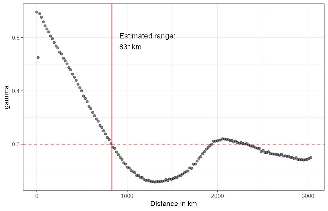
- Covariogram-based bandwidth selection — estimates the spatial correlation range from the empirical covariogram, providing a principled cutoff distance as proposed by Lehner (2026)
- Inverse-U diagnostic plot — visualises how the Conley SE varies with the bandwidth, revealing the inverse-U relationship documented in Lehner (2026)
- Performance — distance matrix computation, kernel weighting, and variance component accumulation are implemented in C++ via Rcpp/RcppArmadillo
Installation
Install the development version from GitHub:
# install.packages("devtools")
devtools::install_github("axlehner/SpatialInference")
macOS note
A Fortran compiler is required for LAPACK/BLAS. If you encounter gfortran issues, see this thread.
Quick start
library(SpatialInference)
library(lfe)
data("US_counties_centroids")

# 1. Estimate the correlation range from the covariogram
covgm_range(US_counties_centroids)
# 2. Compute Conley standard errors at the estimated bandwidth
reg <- felm(noise1 ~ noise2 | unit + year | 0 | lat + lon,
            data = US_counties_centroids, keepCX = TRUE)

vcvs <- conley_SE(reg, unit = "unit", time = "year",
                  lat = "lat", lon = "lon",
                  kernel = "epanechnikov", dist_cutoff = 831)

# Spatial standard errors:
sqrt(diag(vcvs$Spatial))

# Convenience wrapper (returns a single SE):
compute_conley_lfe(reg, cutoff = 831, kernel_choice = "epanechnikov")
# 3. Visualise the inverse-U relationship
inverseu_plot_conleyrange(US_counties_centroids,
                          cutoffrange = seq(1, 2501, by = 200))
Key functions
| Function | Description |
|---|---|
conley_SE() |
Conley spatial HAC variance-covariance matrices (spatial, serial, and combined) |
compute_conley_lfe() |
Convenience wrapper returning a single Conley SE |
covgm_range() |
Estimate and plot the correlation range from a covariogram |
extract_corr_range() |
Extract the zero-crossing range from a covariogram or correlogram |
inverseu_plot_conleyrange() |
Diagnostic plot of SE vs. bandwidth (inverse-U) |
lm_sac() |
All-in-one: regression + Moran's I + Conley SEs |
DistMat() |
Kernel-weighted spatial distance matrix (C++) |
References
Lehner, A. (2026). Bandwidth selection for spatial HAC standard errors. arXiv preprint arXiv:2603.03997. doi:10.48550/arXiv.2603.03997
Conley, T. G. (1999). GMM estimation with cross sectional dependence. Journal of Econometrics, 92(1), 1--45. doi:10.1016/S0304-4076(98)00084-0
Christensen, D., Hartman, A. C. and Samii, C. (2021). Legibility and external investment: An institutional natural experiment in Liberia. International Organization, 75(4), 1087--1108. doi:10.1017/S0020818321000187